

Gerard Mercator, A New and Enlarged Description of the Earth (1569)
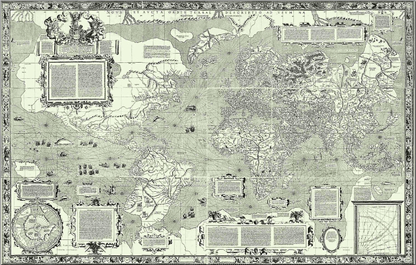
Created by probably the most famous mapmaker in history, Gerard Mercator (1512-1594), this world map is based on his mathematical projection of the world, the first attempt to plot a spherical Earth onto a flat piece of paper. The projection was intended to help ship pilots draw a straight navigational line across the Earth, taking its curvature into account. To achieve this, Mercator stretched the parallels at higher latitudes, making land closer to the North and South Poles appear much larger than they are in reality. Although the map was designed "for use in navigation" as its subtitle suggests, it was drawn at too small a scale to be used by navigators effectively. By the late 17th century though, most ship pilots had adapted it for larger scale maps and it then became the standard projection for long-distance sailing. Despite the scientific advances in the map, though, its geography remains influenced by classical and medieval conventions. It shows sea monsters alongside commerical vessels, a North Pole inhabited by pygmies, and Asia--in the tradition of Ptolemy--is depicted inaccurately.